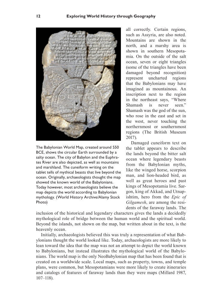
12 Exploring World History through Geography all correctly. Certain regions, such as Assyria, are also noted. Mountains are shown in the north, and a marshy area is shown in southern Mesopota- mia. On the outside of the salt ocean, seven or eight triangles (some of the triangles have been damaged beyond recognition) represent uncharted regions that the Babylonians may have imagined as mountainous. An inscription next to the region in the northeast says, “Where Shamash is never seen.” Shamash was the god of the sun, who rose in the east and set in the west, never touching the northernmost or southernmost regions (The British Museum 2017). Damaged cuneiform text on the tablet appears to describe the lands beyond the bitter salt ocean where legendary beasts from the Babylonian myths, like the winged horse, scorpion man, and lion-headed bird, as well as great heroes and past kings of Mesopotamia live. Sar- gon, king of Akkad, and Utnap- ishtim, hero from the Epic of Gilgamesh, are among the resi- dents of the faraway lands. The inclusion of the historical and legendary characters gives the lands a decidedly mythological role of bridge between the human world and the spiritual world. Beyond the islands, not shown on the map, but written about in the text, is the heavenly ocean. Initially, archaeologists believed this was truly a representation of what Bab- ylonians thought the world looked like. Today, archaeologists are more likely to lean toward the idea that the map was not an attempt to depict the world known to Babylonians, but instead illustrates the mythological world of the Babylo- nians. The world map is the only NeoBabylonian map that has been found that is created on a worldwide scale. Local maps, such as property, towns, and temple plans, were common, but Mesopotamians were more likely to create itineraries and catalogs of features of faraway lands than they were maps (Millard 1987, 107–118). The Babylonian World Map, created around 550 BCE, shows the circular Earth surrounded by a salty ocean. The city of Babylon and the Euphra- tes River are also depicted, as well as mountains and marshland. The cuneiform writing on the tablet tells of mythical beasts that live beyond the ocean. Originally, archaeologists thought the map showed the known world of the Babylonians. Today however, most archaeologists believe the map depicts the world according to Babylonian mythology. (World History Archive/Alamy Stock Photo)
Document Details My Account Print multiple pages
Print
You have printed 0 times in the last 24 hours.
Your print count will reset on at .
You may print 0 more time(s) before then.
You may print a maximum of 0 pages at a time.
Help


